An excursion prompted by coming across a pair of once grand, now rather shabby wrought iron gates, seemingly serving no useful purpose, about where Madans Walk meets Avenue Road, this being perhaps a kilometre to the south of Epsom town centre.
The thought was that these were perhaps the gate to some stately home, either no longer with or no longer visible.
First stop, National Library of Scotland with all their old maps. From which we learn that before the first war, Avenue Road, in the middle of the map above, had not been extended west to Woodcote Road. Very few houses and nothing at the corner in question.
We then roll forward thirty years, by which time Avenue Road had been extended and a house called 'Chandlers' has appeared in about the right place. Note the tongue of garden which appears to extend south into what appear to have been the grounds of Woodcote End House, a little to the north of the junction on which sat the Ladas public house. A decent house, just about within walking range, sadly now converted into flats.
Asking Bing about Chandlers and I learn that these are indeed listed gates. According to reference 1, 'GARDEN WALL, GATE PIERS AND GATES IN MADAN'S WALK BELONGING TO CHANDLERS, AVENUE ROAD', first listed in 1954. Well before the heritage industry got properly underway. Listed gates being a first for me, perhaps for the heritage people too?
While according to a heritage document (reference 2) prepared for Epsom & Ewell council, these are indeed important gates, sadly in a very poor state of repair. Probably some kind of back entrance to Woodcote End House. A bit grand for the servants; perhaps for nocturnal lady visitors?
While back again at 1913 we have a map (with north being left) which suggests that the Woodcote Estate, including its two small stately homes, was sold off in two lots, with the gates quite possibly at the boundary between them.
Gmaps suggests that the pink area was sold off for houses, while Woodcote End House and much of its grounds looks to have survived. No doubt some complicated family history lurking here. With what was the Ladas being just to the right of this snap of Woodcote Road, looking north from near Chalk Lane, from Street View.
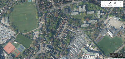
Closing with an aerial view from Ordnance Survey. Madans Walk marked by the line of trees, upper middle, with 'Chandlers' just above the brown blob, presumably a large tree. Atkins Engineering, bottom right, once a jewel in the Epsom crown, now owned by a French Canadian outfit, SNC Lavalin.
Can't help thinking that we should have found a more sensible home for these gates and let 'Chandlers' get on with its suburban life without this large hole in its garden wall. Perhaps the gates could have been pressed into service as gates to the Ashley Centre, in place of what they actually have. Just by what is now Wetherspoons. At least they would have been used there, and been allowed the occasional dab of paint.
PS: I wonder if the Ladbroke Road, top right in the second snap is any relation of Ladbroke Grove, a long and interesting road in west London, running north from Holland Park Avenue, otherwise an extension of the Bayswater Road?
Reference 1: https://historicengland.org.uk/.
Reference 2: Chalk Lane Conservation Area: Character Appraisal & Management Proposals – Epsom & Ewell Borough Council – 2010.


No comments:
Post a Comment